Where does one find the maximum use of maps? In our day to day lives, GPS has marked its importance in enabling a driver to find way through a city. But the essence of map utility is lost in such a case. GPS serves as a solution rather than a map service (that allows end users to learn about a terrain from afar).
If one goes back in time, maps were used by explorers and cartographers treading unknown territories. They served as markers for the areas that had been discovered and marked the boundaries of the unknown. However in the modern day, there is no place on earth that remains unknown and hence maps as tools of discovery have more or less lost their importance. However geologists and armed forces even in the modern times use them extensively.
Military uses maps to assess terrain, create strategies and plan reconnaissance. Map reading is an integral tool for both air and ground forces which are trained in identifying locations of strategic importance. This extensive use has led to the development of the drone technology which has enabled the armed forces across the world to do reconnaissance keeping risk to human lives at bay.
Maps and Drones in Business
Today, many organizations are using the drone technology for assessment of regions which are hazardous for human beings. Petrochemical companies have found drones helpful in assessing ground sites. Some have famously found them as tools for delivery. However there is one business in India that makes use of drones and all the tools used for military tactics for the benefit of its business.
Housing.com is a property portal which is unlike any real estate websites in India.This portal is a technology start up that utilizes data analytics and programming to offer numerous property related services. It is known for its verified listings and innovative offerings. The success of this portal can be assessed by the fact that merely two and half years since its inception, it has become a Rs. 1500 crore company.
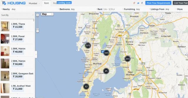
Housing.com was the first company that offered map based search results for property. To understand better, let us assume that an end user is looking for properties for sale in Chennai. He/she can search for properties by typing the locality name. Housing.com shows all the properties as defined by the end user within the confines of the locality, highlighted by markers. It is like an aerial view of the land and the end users can learn about the locality as well as properties.

Use of Drones
Drones are extensively used by the housing portal. They are a handy tool to be used at sites of new project development. The portal sends its agents to verify the project along with a military grade drone. This machine is sent up at the location and it records the video of project under construction and the surrounding areas. This video is then uploaded with every new project that is listed on the portal. If the end user (aforementioned) is looking for new flats for sale in Chennai,then he/she can find the drone video listed with every new project description.
In Conclusion
Housing.com has made the use of the latest technology and revived map features to offer its verified listings. The portal has successfully depicted utility of maps, drones and markers in property business.